XR Indoor wayfinding and discovery
BriteWay XR is a cloud‑based extended‑reality (XR) wayfinding and spatial‑intelligence service that helps public‑sector organisations make complex buildings easier to navigate for all users, including disabled and older people.
The service provides immersive 3D and augmented‑reality guidance, digital twins, and accessibility‑aware routes to support safer, more confident movement through hospitals, campuses, transport hubs, and civic buildings.
BriteWay XR combines indoor positioning, digital mapping, and XR visualisation to deliver step‑by‑step navigation, pre‑visit familiarisation, and real‑time route updates.
The platform integrates with existing building systems and can be deployed across mobile devices, kiosks, and web interfaces. It improves user experience, reduces staff wayfinding burden, and supports inclusive access to public services
Use it as a standalone app or integrated in your app to bring precise location accuracy together with high definition mixed reality (XR) guidance to help visitors plan and navigate your destinations with ease.
Send download link to:Brochure Indoor Mapping
Send download link to:Transport for Wales Case Study

Visual indoor navigation with Augmented Reality

Smarter journey planning with Virtual Tours

Maintain Digital Twin assets

Increase footfall and sales with Insights
")
Improve operational efficiency with Forecasts
What is augmented reality indoor navigation?
Why use augmented reality indoor navigation?
Who is using augmented reality indoor navigation?
Where is augmented reality indoor navigation being used?
Related articles
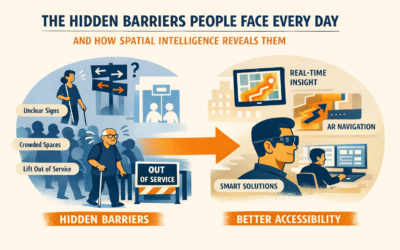
The Hidden Barriers People Face Every Day
Most accessibility barriers aren’t structural — they’re invisible.
They’re the moments of hesitation, confusion, or anxiety that people experience every day in stations, hospitals, campuses, and public buildings. A sign that doesn’t make sense. A lift that’s out of service. A route that’s technically step‑free but emotionally exhausting.
Spatial intelligence reveals these hidden barriers by showing how people actually move — where they slow down, turn back, or feel unsupported.
And once we see those barriers, we can remove them — designing environments that feel intuitive, inclusive, and genuinely human‑centred.
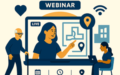
Unlocking Accessibility with Spatial Intelligence: Webinar
Discover how spatial intelligence is transforming accessibility — and why it matters now more than ever.
Join Briteyellow’s upcoming webinar to explore how AI-powered behavioural insight, privacy-safe sensing, and smart navigation tools are helping transport operators, property managers, and public-sector teams create environments that truly work for everyone.
From heatmaps and flow analytics to AR guidance and smart glasses, we’ll show how technology can reveal hidden barriers, support independent movement, and deliver measurable impact — without burdening users or compromising privacy.

AR Navigation and Smart Glasses
AR navigation and smart glasses are changing how people move — not just through stations, but through hospitals, campuses, and public buildings.
By overlaying personalised guidance onto the real world, these tools restore confidence, reduce stress, and support truly independent movement.
Discover how Briteyellow’s spatial intelligence platform is making environments more intuitive, inclusive, and human‑centred — one step at a time.