XR Indoor wayfinding and discovery
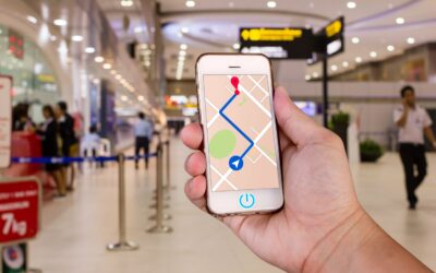
BriteWay XR is a cloud‑based extended‑reality (XR) wayfinding and spatial‑intelligence service that helps public‑sector organisations make complex buildings easier to navigate for all users, including disabled and older people.
The service provides immersive 3D and augmented‑reality guidance, digital twins, and accessibility‑aware routes to support safer, more confident movement through hospitals, campuses, transport hubs, and civic buildings.
BriteWay XR combines indoor positioning, digital mapping, and XR visualisation to deliver step‑by‑step navigation, pre‑visit familiarisation, and real‑time route updates.
The platform integrates with existing building systems and can be deployed across mobile devices, kiosks, and web interfaces. It improves user experience, reduces staff wayfinding burden, and supports inclusive access to public services
Use it as a standalone app or integrated in your app to bring precise location accuracy together with high definition mixed reality (XR) guidance to help visitors plan and navigate your destinations with ease.
Send download link to:Brochure Indoor Mapping
Send download link to:Transport for Wales Case Study

Visual indoor navigation with Augmented Reality

Smarter journey planning with Virtual Tours

Maintain Digital Twin assets

Increase footfall and sales with Insights
")
Improve operational efficiency with Forecasts
What is augmented reality indoor navigation?
Why use augmented reality indoor navigation?
Who is using augmented reality indoor navigation?
Where is augmented reality indoor navigation being used?
Related articles

Transported to the future….
Huge challenges face the operators of transport hubs over the next decade as the nature of mobility changes. Driverless cars are set to challenge the very need for collective overland movement from one fixed point to another fixed point. There will be no need for...
Retail apocalypse demands tech response
We’re living in the midst of a retail apocalypse. Not a Biblical-style end of-the-world apocalypse, maybe, but one certainly involving “destruction or damage on a catastrophic scale” as one dictionary definition has it. KPMG, the auditing giants, say some 44...

What is an Indoor Positioning System and how does it work?
You are no doubt familiar with the concept of using GPS to navigate around the road network using your SatNav. A plethora of smartphone applications and outdoor navigation solutions now sit comfortably in dashboards and phone holders of consumers around the globe. ...